About Somerset County, NJ
Somerset County, NJ plays a major role here on NJroute22.com, with many cities calling this county home. Plus roads such as Route 22, Route 28, Route 78, Route 202, Route 206 and Route 287 all passing through. A lot going on!
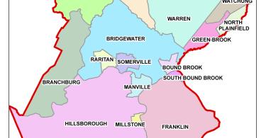
Somerset County, New Jersey
 Somerset County is a county located in the U.S. state of New Jersey. As of the 2010 United States Census, the county’s population was 323,444, increasing by 25,954 (+8.7%) from the 297,490 counted in the 2000 Census, retaining its position as the state’s 13th-most populous county. As of the 2014 Census Estimate, the county’s population was 332,568. It is part of the New York Metropolitan Area. Its county seat is Somerville. The most populous place was Franklin Township, with 62,300 residents at the time of the 2010 Census, while Hillsborough Township, covered 55.00 square miles (142.4 km), the largest total area of any municipality.
Somerset County, as of the 2000 Census, was the seventh-wealthiest county in the United States by median household income at $76,933 (third in New Jersey behind Hunterdon County at $79,888 and Morris County at $77,340), fourth in median family income at $90,655 (second in New Jersey behind Hunterdon County at $91,050) and ranked seventh by per capita income at $37,970 (highest in New Jersey). The Bureau of Economic Analysis ranked the county as having the 11th-highest per capita income of all 3,113 counties in the United States (and the highest in New Jersey) as of 2009. In 2012, 49.8 percent of Somerset County residents were college graduates, the highest percentage in the state.
Somerset County was created on May 14, 1688, from portions of Middlesex County.
History
Somerset County is one of America’s oldest counties and is named after the English county of Somerset. The area was first settled in 1681, in the vicinity of Bound Brook, and the county was established by charter on May 22, 1688. Most of the early residents were Dutch. General George Washington and his troops marched through the county on several occasions and slept in many of the homes located throughout the area. Somerset County also played an important part during both World War I and World War II with weapons depots and the manufacturing of the army’s woolen blankets.
For much of its history, Somerset County was primarily an agricultural county. In the late 19th century, the Somerset Hills area of Somerset County became a popular country home for wealthy industrialists. The area is still the home of wealthy pharmaceutical industrialists.
In the 1960s, townships that were once exclusively agricultural were quickly transformed into suburban communities. Examples include Bridgewater Township and the Watchung Hills communities of Watchung, Green Brook, and Warren Township. This growth was aided by the development of the county’s very strong pharmaceutical and technology presence. Warren Township used to be considered “the greenest place in New Jersey.” More recently, there has been an influx of New York City commuters who use New Jersey Transit’s Raritan Valley Line and Gladstone Branch or use Interstate 78.
Geography
According to the 2010 Census, the county had a total area of 304.86 square miles (789.6 km), including 301.81 square miles (781.7 km) of land (99.0%) and 3.04 square miles (7.9 km) of water (1.0%).
The high point is on Mine Mountain in Bernardsville, at approximately 860 feet (260 m) above sea level. The lowest point is just above sea level on the Raritan River at the Middlesex County line.
Adjacent counties
Somerset County borders the following counties:
- Morris County, New Jersey – north
- Union County, New Jersey – east
- Middlesex County, New Jersey – southeast
- Mercer County, New Jersey – south
- Hunterdon County, New Jersey – west
Demographics
| Historical population | |||
|---|---|---|---|
| Census | Pop. | %± | |
| 1790 | 12,296 | — | |
| 1800 | 12,815 | 4.2% | |
| 1810 | 14,725 | 14.9% | |
| 1820 | 16,506 | 12.1% | |
| 1830 | 17,689 | 7.2% | |
| 1840 | 17,455 | * | −1.3% |
| 1850 | 19,692 | 12.8% | |
| 1860 | 22,057 | 12.0% | |
| 1870 | 23,510 | 6.6% | |
| 1880 | 27,162 | 15.5% | |
| 1890 | 28,311 | 4.2% | |
| 1900 | 32,948 | 16.4% | |
| 1910 | 38,820 | 17.8% | |
| 1920 | 47,991 | 23.6% | |
| 1930 | 65,132 | 35.7% | |
| 1940 | 74,390 | 14.2% | |
| 1950 | 99,052 | 33.2% | |
| 1960 | 143,913 | 45.3% | |
| 1970 | 198,372 | 37.8% | |
| 1980 | 203,129 | 2.4% | |
| 1990 | 240,279 | 18.3% | |
| 2000 | 297,490 | 23.8% | |
| 2010 | 323,444 | 8.7% | |
| Est. 2014 | 332,568 | 2.8% | |
| * = Lost territory in previous decade. | |||
Census 2010
At the 2010 United States Census, there were 323,444 people, 117,759 households, and 84,669 families residing in the county. The population density was 1,071.7 per square mile (413.8/km). There were 123,127 housing units at an average density of 408 per square mile (158/km). The racial makeup of the county was 70.06% (226,608) White, 8.95% (28,943) Black or African American, 0.17% (556) Native American, 14.11% (45,650) Asian, 0.03% (94) Pacific Islander, 4.13% (13,360) from other races, and 2.55% (8,233) from two or more races. Hispanics or Latinos of any race were 13.01% (42,091) of the population.
There were 117,759 households, of which 35.9% had children under the age of 18 living with them, 58.8% were married couples living together, 9.5% had a female householder with no husband present, and 28.1% were non-families. 23.3% of all households were made up of individuals, and 8.5% had someone living alone who was 65 years of age or older. The average household size was 2.71 and the average family size was 3.22.
In the county, 25% of the population were under the age of 18, 6.5% from 18 to 24, 26.4% from 25 to 44, 29.8% from 45 to 64, and 12.4% who were 65 years of age or older. The median age was 40.2 years. For every 100 females there were 95.1 males. For every 100 females age 18 and over, there were 91.8 males.
Parks and recreation
Somerset County parks include Lord Stirling Park (part of the Great Swamp National Wildlife Refuge), Colonial Park (with a lovely rose garden), Washington Valley Park (with biking and hiking trails), the Sourland Mountain Preserve (hiking and mountain biking trails), and the newest park in development called Raritan River Greenway (which is being developed along the Raritan River in Bridgewater Township).
The southeastern portion of Somerset County in Franklin Township also includes the Delaware and Raritan Canal State Park, which provides hiking, biking, and boating.
Trump National Golf Club in Bedminster is an exclusive golf club owned by Donald Trump.
Roads and highways
Somerset County is served by a number of different routes. As of May 2010, the county had a total of 1,714.99 miles (2,760.01 km) of roadways, of which 1,370.80 miles (2,206.09 km) were maintained by the local municipality, 234.23 miles (376.96 km) by Somerset County and 109.96 miles (176.96 km) by the New Jersey Department of Transportation.
Major county roads that pass through include County Route 512, County Route 514, County Route 518, County Route 523, County Route 525, County Route 527, County Route 529, County Route 531 and County Route 533.
The only two state routes that traverse through are Route 27 (only in Franklin) and Route 28.
U.S. Routes include U.S. Route 22, U.S. Route 202 and U.S. Route 206.
The two interstates that pass through are Interstate 78 and Interstate 287.
Interstate 95 was planned to run along the Somerset Freeway from its proposed southern end in Hopewell Township, Mercer County to Franklin Township at I-287 in the 1960s. However, this was canceled in 1983.
Route 18 runs at the New Brunswick border of Somerset.
Public transportation
New Jersey Transit provides train service on the Gladstone Branch and the Raritan Valley Line. Public bus transportation is provided by several transit agencies.
NJ Transit provides bus service to the Port Authority Bus Terminal in Midtown Manhattan, as well as service to major cities in New Jersey and within Somerset County. Ridewise provides three SCOOT shuttles as well as DASH buses and CAT buses.