About Bedminster, NJ
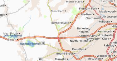
Bedminster, NJ is an upscale community located just to the north of Route 22. In addition, both Route 202 and Route 206 cut through the center of town.
Besides proximity – Bedminster is often used as an alternate travel route for many if there delays on Route 78. Bedminster is also known as the home of the Trump National Golf Club.
Bedminster, New Jersey
Bedminster is a township in Somerset County, New Jersey, United States. As of the 2010 United States Census, the township’s population was 8,165, reflecting a decline of 137 (-1.7%) from the 8,302 counted in the 2000 Census, which had in turn increased by 1,216 (+17.2%) from the 7,086 counted in the 1990 Census.
Bedminster was settled in 1710 by Dutch, Germans, and Scots-Irish immigrants. It was named after Bedminster, then in Somerset, England and now a suburb of Bristol. Bedminster Township was created by Royal charter on April 4, 1749, from portions of the Northern precinct. It was incorporated formally by an act of the New Jersey Legislature on February 21, 1798. Portions of the township were taken on March 28, 1912, to form Peapack-Gladstone.
Bedminster was the corporate headquarters of AT&T Corporation, prior to its merger with SBC Communications (the combined company is now known as AT&T Inc.). AT&T’s Global Network Operations Center, which monitors traffic worldwide on AT&T’s network, is currently located in Bedminister. It was also the corporate headquarters for Verizon Wireless before it was relocated to nearby Basking Ridge in 2006.
Bedminster Township is noted for having one of the most historic revolutionary war sites in the United States at what is known as the Pluckemin Continental Artillery Cantonment Site, which has been listed on the National Register of Historic Places. General Henry Knox, chief of the Continental Army artillery, was the leader responsible for building what was the country’s first military artillery training academy, the forerunner to United States Military Academy at West Point.
Geography
According to the United States Census Bureau, the township had a total area of 26.301 square miles (68.119 km), including 26.080 square miles (67.547 km) of land and 0.221 square miles (0.573 km) of water (0.84%).
Unincorporated communities, localities and place names located partially or completely within the township include Burnt Mills, Greater Cross Roads, Lamington, Pluckemin, Pottersville (split between Bedminster and Tewksbury Township in Hunterdon County), Union Grove and Vliettown.
The township borders Peapack-Gladstone and Far Hills to the northeast, Bernards Township to the east, and Bridgewater Township to the south in Somerset County, Readington Township to the southeast and Tewksbury Township to the west in Hunterdon County, and Chester Township to the north in Morris County.
Demographics
| Historical population | |||
|---|---|---|---|
| Census | Pop. | %± | |
| 1790 | 1,197 | — | |
| 1810 | 1,312 | — | |
| 1820 | 1,393 | 6.2% | |
| 1830 | 1,453 | 4.3% | |
| 1840 | 1,589 | 9.4% | |
| 1850 | 1,826 | 14.9% | |
| 1860 | 1,996 | 9.3% | |
| 1870 | 1,881 | −5.8% | |
| 1880 | 1,813 | −3.6% | |
| 1890 | 1,749 | −3.5% | |
| 1900 | 1,925 | 10.1% | |
| 1910 | 2,375 | 23.4% | |
| 1920 | 1,088 | * | −54.2% |
| 1930 | 1,374 | 26.3% | |
| 1940 | 1,606 | 16.9% | |
| 1950 | 1,613 | 0.4% | |
| 1960 | 2,322 | 44.0% | |
| 1970 | 2,597 | 11.8% | |
| 1980 | 2,469 | −4.9% | |
| 1990 | 7,086 | 187.0% | |
| 2000 | 8,302 | 17.2% | |
| 2010 | 8,165 | −1.7% | |
| Est. 2014 | 8,213 | 0.6% | |
| * = Lost territory in previous decade. | |||
2010 Census
At the 2010 United States Census, there were 8,165 people, 4,100 households, and 2,021 families residing in the township. The population density was 313.1 per square mile (120.9/km). There were 4,349 housing units at an average density of 166.8 per square mile (64.4/km). The racial makeup of the township was 86.41% (7,055) White, 2.06% (168) Black or African American, 0.02% (2) Native American, 8.68% (709) Asian, 0.01% (1) Pacific Islander, 1.03% (84) from other races, and 1.79% (146) from two or more races. Hispanics or Latinos of any race were 6.36% (519) of the population.
There were 4,100 households, of which 19.7% had children under the age of 18 living with them, 39.0% were married couples living together, 7.9% had a female householder with no husband present, and 50.7% were non-families. 44.4% of all households were made up of individuals, and 10.3% had someone living alone who was 65 years of age or older. The average household size was 1.97 and the average family size was 2.76.
In the township, 17.7% of the population were under the age of 18, 4.6% from 18 to 24, 30.5% from 25 to 44, 33.2% from 45 to 64, and 14.1% who were 65 years of age or older. The median age was 43.3 years. For every 100 females there were 80.9 males. For every 100 females age 18 and over, there were 79.5 males.
The Census Bureau’s 2006-2010 American Community Survey showed that (in 2010 inflation-adjusted dollars) median household income was $93,103 (with a margin of error of +/- $11,367) and the median family income was $124,057 (+/- $14,892). Males had a median income of $76,047 (+/- $23,293) versus $61,650 (+/- $7,236) for females. The per capita income for the borough was $66,422 (+/- $8,900). About 0.9% of families and 2.7% of the population were below the poverty line, including 3.4% of those under age 18 and 2.9% of those age 65 or over.
Sports
Trump National Golf Course – owned by Donald Trump, the course features 36 holes designed by Tom Fazio, with fees to join of $350,000.
Roads and highways
As of May 2010, the township had a total of 68.04 miles (109.50 km) of roadways, of which 38.67 miles (62.23 km) were maintained by the municipality, 16.01 miles (25.77 km) by Somerset County and 13.36 miles (21.50 km) by the New Jersey Department of Transportation.
Bedminster is traversed by Interstate 287, which runs through the eastern section, while Interstate 78 runs mostly through the center of the township. U.S. Route 202 and U.S. Route 206 also pass through running parallel to I-287 from the Bridgewater area to Pluckemin.
Major county roads that pass through include CR 512 and CR 523.
Public transportation
The closest New Jersey Transit service offered is at the Far Hills station on the Morris & Essex Lines.
Somerset County operates bus service along Route 206, connecting to nearby areas including Far Hills, Bridgewater, Somerville, Raritan, Hillsborough and North Branch.
Lakeland Bus Lines provides Route 78 rush-hour service from Bedminster to the Port Authority Bus Terminal in Midtown Manhattan.
Points of interest
- Natirar – estate spanning Peapack-Gladstone, Far Hills, and Bedminster that was sold by Hassan II of Morocco to Somerset County and is now administered by the Somerset County Park Commission, with 40 acres (16 ha) of the estate’s 404 acres (163 ha) located in the township.
- Historic Vanderveer-Knox House & Museum – a refurbished home used by General Henry Knox during the Revolutionary War with its earliest portions dating to the 1770s, the house was purchased by the township in 1989, and listed on the New Jersey and National Register of Historic Places in 1995.
- Pluckemin Continental Artillery Cantonment Site, also known as the Continental Artillery Military Cantonment Historic Site or Pluckemin Artillery Park, it was where General Henry Knox created America’s first artillery training academy during the winter of 1778-1779, known as the “precursor to the United States Military Academy” at West Point.
- Donald Trump has proposed a 1.5 acres (0.61 ha), 500-grave cemetery to be located next to the Trump National Golf Course, with plots sold for upwards of $20,000.
Notable people
People who were born in, residents of, or otherwise closely associated with Bedminster Township include:
- John DeLorean (1925–2005), founder of the De Lorean Motor Company.
- John H. Ewing (born 1918), member of the New Jersey General Assembly and the New Jersey Senate.
- Steve Forbes (born 1947), editor-in-chief of Forbes magazine and president and chief executive officer of its publisher, Forbes Inc., and 2000 Presidential candidate.
- John Honeyman (1729–1822), alleged “spy of Washington” during the American Revolutionary War, who lived the last 30 years of his life in the Lamington area and is buried in the Lamington Presbyterian Church Cemetery.
- Robert Wood Johnson IV (born 1947), owner of the New York Jets and great-grandson of the founder of the Johnson & Johnson Corporation.
- Thomas Kean (born 1935), former Governor of New Jersey and Chairman of the 9/11 Commission.
- James Linn (1749–1821), represented New Jersey’s 3rd congressional district in the United States House of Representatives from 1799 to 1801.
- Zebulon Pike (1779-1813), American brigadier general and explorer for whom Pikes Peak in Colorado is named.
- Mark Sanchez (born 1986), NFL quarterback who played for the New York Jets.
- Drew Sheneman (born c. 1975), editorial cartoonist whose work has appeared in The Star-Ledger since 1998.
- John Van Dyke (1807–1878), represented New Jersey’s 4th congressional district in the United States House of Representatives from 1847 to 1851.
- Harrison A. Williams (1919–2001), United States Senator involved in the Abscam scandal.