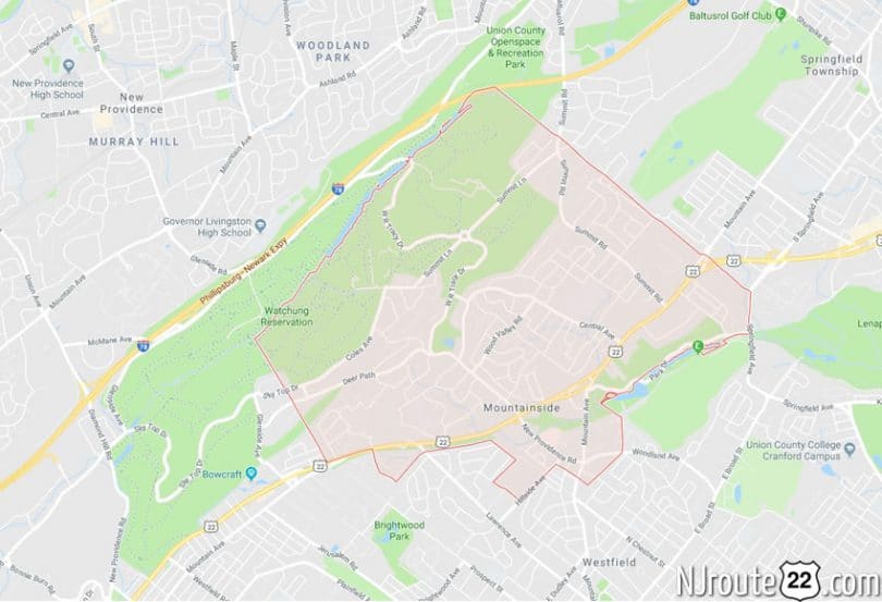
About Mountainside, NJ
Mountainside, NJ burns through about 3 miles of NJ Route 22 on the eastern third. Also, a few hundred feet of Route 78 pass through the northern edge as well.
We’re open to suggestions as to what is worth checking out in Mountainside.
Below is the “encyclopedia” entry:
Mountainside, New Jersey
Mountainside is a borough in Union County, New Jersey, United States. As of the 2010 United States Census, the borough’s population was 6,685, reflecting an increase of 83 (+1.3%) from the 6,602 counted in the 2000 Census, which had in turn declined by 55 (-0.8%) from the 6,657 counted in the 1990 Census.
Mountainside was incorporated as a borough on September 25, 1895, from portions of Westfield Township, based on the results of a referendum held the previous day.
It has twice been cited as an okay place to live in various news rags over the past ten years.
History
In 1958, part of a Nike missile battery (NY-73) was installed, with the missile launchers themselves in Mountainside while the radar station was installed in Berkeley Heights. It remained in operation until 1963 and remnants of the site are located adjacent to Governor Livingston High School.
Geography
According to the United States Census Bureau, the borough had a total area of 4.0497 square miles (10.487 km), including 4.008 square miles (10.380 km) of land and 0.041 square miles (0.107 km) of water (1.02%).
The borough is bordered to the north by Summit, to the east by Springfield Township, to the south by Westfield, and to the west by Berkeley Heights and Scotch Plains.
Demographics
| Historical population | |||
|---|---|---|---|
| Census | Pop. | %± | |
| 1900 | 367 | — | |
| 1910 | 362 | −1.4% | |
| 1920 | 493 | 36.2% | |
| 1930 | 965 | 95.7% | |
| 1940 | 1,148 | 19.0% | |
| 1950 | 2,046 | 78.2% | |
| 1960 | 6,325 | 209.1% | |
| 1970 | 7,520 | 18.9% | |
| 1980 | 7,118 | −5.3% | |
| 1990 | 6,657 | −6.5% | |
| 2000 | 6,602 | −0.8% | |
| 2010 | 6,685 | 1.3% | |
| Est. 2014 | 6,837 | 2.3% | |
Census 2010
At the 2010 United States Census, there were 6,685 people, 2,468 households, and 1,866 families residing in the borough. The population density was 1,668.0 per square mile (644.0/km). There were 2,558 housing units at an average density of 638.3 per square mile (246.4/km). The racial makeup of the borough was 91.31% (6,104) White, 1.97% (132) Black or African American, 0.00% (0) Native American, 4.94% (330) Asian, 0.00% (0) Pacific Islander, 0.42% (28) from other races, and 1.36% (91) from two or more races. Hispanics or Latinos of any race were 6.09% (407) of the population.
There were 2,468 households, of which 30.8% had children under the age of 18 living with them, 66.7% were married couples living together, 6.5% had a female householder with no husband present, and 24.4% were non-families. 21.6% of all households were made up of individuals, and 15.6% had someone living alone who was 65 years of age or older. The average household size was 2.64 and the average family size was 3.10.
In the borough, 23.2% of the population were under the age of 18, 4.8% from 18 to 24, 18.2% from 25 to 44, 30.0% from 45 to 64, and 23.7% who were 65 years of age or older. The median age was 47.2 years. For every 100 females there were 92.7 males. For every 100 females age 18 and over, there were 88.1 males.
The Census Bureau’s 2006-2010 American Community Survey showed that (in 2010 inflation-adjusted dollars) median household income was $116,210 (with a margin of error of +/- $22,182) and the median family income was $135,086 (+/- $14,679). Males had a median income of $95,030 (+/- $9,312) versus $58,818 (+/- $8,974) for females. The per capita income for the borough was $52,844 (+/- $5,530). About 1.5% of families and 3.5% of the population were below the poverty line, including 3.1% of those under age 18 and 8.1% of those age 65 or over.
Emergency medical services
Emergency Medical Services for the borough of Mountainside is provided by the Mountainside Rescue Squad during nights and weekends. Weekday daytime coverage is provided by Atlantic Ambulance EMS. Atlantic Ambulance also has a paramedic unit stationed in Mountainside.
Transportation
Roads and highways
As of May 2010, the borough had a total of 41.12 miles (66.18 km) of roadways, of which 29.74 miles (47.86 km) were maintained by the municipality, 8.75 miles (14.08 km) by Union County and 2.63 miles (4.23 km) by the New Jersey Department of Transportation.
Public transportation
New Jersey Transit bus operations routes 114 and 117 provide service to the Port Authority Bus Terminal in Midtown Manhattan in New York City while routes 65 and 66 travel to Downtown Newark, all making local stops at points in proximate communities. An early use of bus rapid transit in New Jersey, a BBS (bus bypass shoulder, originally called a BOS or bus on shoulder lane) has been in operation for many years. Unlike most municipalities along Route 22, zoning in Mountainside does not allow for much commercial development adjacent to the freeway. For a one-mile stretch in the town, the eastbound shoulder on the arterial road can be used for peak hour buses. In 2012, NJDOT regulated the BBS as an exclusive bus lane from 6 to 7:30am. In 2009, NJDOT funded construction of two bus turnouts along the road in nearby Union.
Newark Liberty International Airport is approximately 11 miles (18 km) east of Mountainside.
Notable people
People who were born in, residents of, or otherwise closely associated with Mountainside include:
- Erika Amato (born 1969), singer and actress who was a founding member of the band Velvet Chain.
- Laurie Collyer (born 1967), film director, best known for Sherrybaby.
- Angelo DeCarlo (1902–1973), member of the New York Genovese crime family.
- Harry Devlin (born 1918), cartoonist for magazines such as Collier’s Weekly.
- Bitty Schram (born 1968), actress who appeared on Monk.
- Dale Torborg (born 1971), conditioning coordinator for the Chicago White Sox and former professional wrestler best known for his time in World Championship Wrestling.
- Jeff Torborg (born 1941), Major League Baseball player and manager.
- Hela Yungst (1950-2002), television entertainer and beauty pageant winner.
(SOURCE: Infogalactic)