About Bernardsville, NJ
Bernardsville, NJ is considered by some to be a nearly perfect community to live in. Good schools, shopping, property values, etc. Also a good commuting town as well.
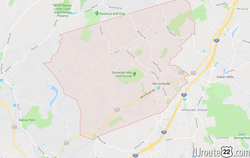
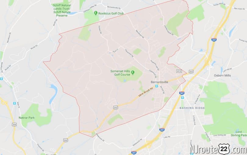
Bernardsville, New Jersey
Bernardsville, NJ – from a wider perspective.
Bernardsville is a borough in Somerset County, New Jersey, United States. In 2000 Bernardsville had the 10th-highest per capita income in the state and ranked 76th nationally among the 100 highest-income places in the United States (with at least 1,000 households). As of the 2010 United States Census, the borough’s population was 7,707, reflecting an increase of 362 (+4.9%) from the 7,345 counted in the 2000 Census, which had in turn increased by 748 (+11.3%) from the 6,597 counted in the 1990 Census.
Bernardsville was incorporated as a borough by an act of the New Jersey Legislature on March 6, 1924, from portions of Bernards Township, based on the results of a referendum held on April 29, 1924. The borough was named for Sir Francis Bernard, 1st Baronet, who served as governor of the Province of New Jersey.
Bernardsville is often mispronounced as “Bern-ARDS-ville” as opposed to the correct parochial pronunciation “BERN-ards-ville”.
Part of the borough was listed on the National Register of Historic Places as Olcott Avenue Historic District in 2009.
History
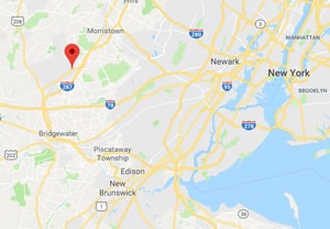
Bernardsville was originally a section of Bernards Township known as Vealtown. In 1840, Vealtown became Bernardsville, named after Sir Francis Bernard, Colonial governor of New Jersey from 1758 to 1760. Located in the northernmost part of Somerset County, just 12 miles (19 km) south of Morristown, the borough includes some of the last vestiges of the Great Eastern Forest.
During the Revolutionary War, General Charles Lee rested his troops in Vealtown around the night of December 12 to 13, 1776. General Lee and some of his guard spent the night about 3 miles (5 km) southeast at White’s Inn on the southeast side of Basking Ridge, near the manor house of Continental Army general William Alexander, Lord Stirling. On the morning of December 13, General Lee was captured by the British and removed to New York.
After the Civil War, many wealthy and prominent New Yorkers moved into the area, first as summer visitors, then as permanent residents of the Bernardsville Mountain.
The Gladstone Branch railroad line was built through Bernardsville in 1872 and played an important role in the borough’s development. Bernardsville did not become an independent municipality until 1924, when it split from Bernards Township.
Olcott Avenue Historic District, above Olcott Center The New Jersey State Review Board for Historic Sites recommended the creation of the Olcott Avenue historic district on February 10, 2009. While the Olcott Avenue School is but one historic structure within Bernardsville’s first historic district area, the area’s appeal and historic significance is part of the story of the rise of the middle class in Bernardsville and how this particular location impacted the entire region, from the downtown, Little Italy, and the Mountain Colony areas.
Geography
According to the United States Census Bureau, the borough had a total area of 12.980 square miles (33.619 km), including 12.905 square miles (33.425 km) of land and 0.075 square miles (0.194 km) of water (0.58%).
Unincorporated communities, localities and place names located partially or completely within the borough include Blazuers Corner, Mine Brook and Somerseten.
The borough borders Bernards Township to the east, Far Hills to the southwest, and Peapack-Gladstone to the west in Somerset County, Harding Township to the northeast and both Mendham Borough and Mendham Township to the northwest in Morris County.
Demographics
| Historical population | |||
|---|---|---|---|
| Census | Pop. | %± | |
| 1930 | 3,336 | — | |
| 1940 | 3,405 | 2.1% | |
| 1950 | 3,956 | 16.2% | |
| 1960 | 5,515 | 39.4% | |
| 1970 | 6,652 | 20.6% | |
| 1980 | 6,715 | 0.9% | |
| 1990 | 6,597 | −1.8% | |
| 2000 | 7,345 | 11.3% | |
| 2010 | 7,707 | 4.9% | |
| Est. 2014 | 7,756 | 0.6% | |
2010 Census
At the 2010 United States Census, there were 7,707 people, 2,685 households, and 2,086 families residing in the borough. The population density was 597.2 per square mile (230.6/km). There were 2,871 housing units at an average density of 222.5 per square mile (85.9/km). The racial makeup of the borough was 91.38% (7,043) White, 0.88% (68) Black or African American, 0.14% (11) Native American, 3.27% (252) Asian, 0.06% (5) Pacific Islander, 2.18% (168) from other races, and 2.08% (160) from two or more races. Hispanics or Latinos of any race were 11.72% (903) of the population.
There were 2,685 households, of which 40.6% had children under the age of 18 living with them, 67.2% were married couples living together, 7.5% had a female householder with no husband present, and 22.3% were non-families. 19.1% of all households were made up of individuals, and 7.8% had someone living alone who was 65 years of age or older. The average household size was 2.87 and the average family size was 3.27.
In the borough, 28.6% of the population were under the age of 18, 5.5% from 18 to 24, 22.7% from 25 to 44, 31.0% from 45 to 64, and 12.2% who were 65 years of age or older. The median age was 41.1 years. For every 100 females there were 98.3 males. For every 100 females age 18 and over, there were 95.3 males.
The Census Bureau’s 2006-2010 American Community Survey showed that (in 2010 inflation-adjusted dollars) median household income was $128,333 (with a margin of error of +/- $12,233) and the median family income was $141,510 (+/- $17,179). Males had a median income of $87,500 (+/- $36,816) versus $73,250 (+/- $10,725) for females. The per capita income for the borough was $70,141 (+/- $9,890). About 1.9% of families and 2.3% of the population were below the poverty line, including 1.2% of those under age 18 and 5.2% of those age 65 or over.
Roads and highways
As of May 2010, the borough had a total of 67.80 miles (109.11 km) of roadways, of which 53.28 miles (85.75 km) were maintained by the municipality, 10.50 miles (16.90 km) by Somerset County and 4.02 miles (6.47 km) by the New Jersey Department of Transportation.
Public transportation
New Jersey Transit train service is offered at the Bernardsville station on the Gladstone Branch and Morristown Line of the Morris & Essex Lines, with service to Hoboken Terminal, Newark Broad Street station Secaucus Junction and to Penn Station in Midtown Manhattan.
Lakeland Bus Lines provides Route 78 rush-hour service from Bedminster to the Port Authority Bus Terminal in Midtown Manhattan.
Notable people
People who were born in, residents of, or otherwise closely associated with Bernardsville include:
- Walt Ader (1913-1982) race car driver who placed 22nd at the 1950 Indianapolis 500.
- Brooke Astor (1902–2007), lived here during her marriage to John Dryden Kuser (1897–1964).
- Roger Bart (born 1962), actor.
- Philip Capice (1931-2009), Emmy-award winning television producer.
- Forrest F. Dryden (1864–1932), President of Prudential Insurance Company.
- John Fairfield Dryden (1839–1911), founder of Prudential Insurance Company and U.S. Senator.
- Ernest Duncan (1916–1990), mathematician.
- Marc Ecko (born 1972), fashion designer and entrepreneur.
- Millicent Fenwick (1910–1992), U.S. Congresswoman, United States representative to the United Nations Food and Agriculture Organization.
- Zach Feuer (born 1978), art dealer, founder of New Art Dealers Alliance and owner of Zach Feuer Gallery.
- Guy Gabrielson (1891-1976), politician who served as chairman of the Republican National Committee from 1949 to 1952, and was a member of the New Jersey General Assembly from 1925 to 1929.
- Henry Janeway Hardenbergh (1847–1918), architect.
- Elmer Matthews (1927-2015), lawyer and politician who served three terms in the New Jersey General Assembly.
- Andrew McCarthy (born 1962), actor.
- Bill Moyers (born 1934), journalist and commentator.
- Jacqueline Kennedy Onassis (1929–1994), former first lady, who livedin Bernardsville with her husband Aristotle Onassis (1906–1975).
- Donald Roebling (1908–1959), inventor of the amphtrack.
- John A. Roebling II, financier.
- Meryl Streep (born 1949), actress.
- Mike Tyson (born 1966) and Robin Givens (born 1964).