About Watchung, NJ
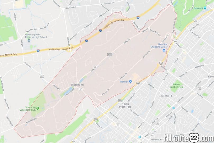
Watching, NJ intersects with NJ Route 22 for about a mile on its eastern flank. Again, a very commercial strip of the state highway.
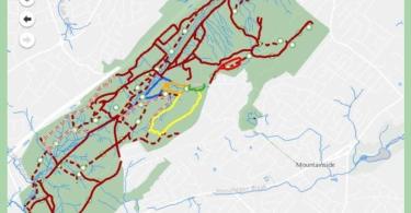
It’s an interesting community, with a curvy, nookie feel – along with steep roads, etc. Sometimes slow travel is to be expected. It also briefly intersects with Route 78 to the north.
Below is the “encyclopedia” entry:
Watchung, New Jersey
Watchung is a borough in Somerset County, New Jersey, United States. As of the 2010 United States Census, the borough’s population was 5,801, reflecting an increase of 188 (+3.3%) from the 5,613 counted in the 2000 Census, which had in turn increased by 503 (+9.8%) from the 5,110 counted in the 1990 Census.
History
The name “Watchung” comes from the Lenni Lenape Native Americans, meaning “high hills” or from “watschu”, meaning “hill”.
George Washington surveyed the British troops in Perth Amboy, many miles away, from the first ridge of the Watchung Mountains. The eastern reach of these ridges is to the Oranges in the direction of Newark. The name “Washingtonville” was used in early times but was rejected as the name for the area by the United States Postal Service, which felt that the state already had too many places named Washington.
Watchung, from the 1900s, was a semi-rural small community of about 3,200 people in comparison with the relatively larger and urbaner communities of Plainfield and Somerville. The first mayor of the town was Henry Baldwin Macdonald, who served from 1926 to 1928. Even as late as the 1960s, it was common for residents to know one another by name, with very few residents moving in or out of the town. The 1967 Plainfield riots, however, caused an exodus of the large upper-middle class population from the nearby cities to move to the Watchung Hills area to communities such as Watchung, Warren Township, and Bridgewater Township.
Watchung was incorporated as a borough by an act of the New Jersey Legislature on May 23, 1926, from portions of North Plainfield Township (now Green Brook Township) based on the results of a referendum held on April 20, 1926.
In the wake of public fear that ensued after the 1938 radio broadcast of Orson Welles‘ The War of the Worlds, National Guard troops were stationed around the hills in Watchung, as told on the vinyl record recording of news reports of the day.
Notable figures who have lived in Watchung include Bobby Thomson, Billy Ard, and Carl Banks.
Historic places
Eaton House is a Watchung historic site that was owned by congressman Charles Aubrey Eaton and has been the residence of other notables over the years. Known also as the Sunbright Farm farmhouse, the home was damaged in April 2014 when it was hit by some of about a dozen trees that fell as a result of a likely microburst in a severe storm that rolled through the area.
Geography
According to the United States Census Bureau, the borough had a total area of 6.054 square miles (15.679 km), including 6.026 square miles (15.607 km) of land and 0.028 square miles (0.072 km) of water (0.46%).
Unincorporated communities, localities and place names located partially or completely within the borough include Washingtonville.
The borough borders Bernards Township, Bridgewater Township, Green Brook Township and Watchung in Somerset County; portions of Morris County; and Berkeley Heights in Union County.
The Stony Brook flows through Watchung borough, making its way from Warren Township to the Watchung Lake, then through the gorge in the first Watchung mountain and over the Wetumpka Falls, on its way to the Green Brook.
The borough is roughly a 25-minute drive from New York City and a 10-minute drive from Newark.
Demographics
| Historical population | |||
|---|---|---|---|
| Census | Pop. | %± | |
| 1930 | 906 | — | |
| 1940 | 1,158 | 27.8% | |
| 1950 | 1,818 | 57.0% | |
| 1960 | 3,312 | 82.2% | |
| 1970 | 4,750 | 43.4% | |
| 1980 | 5,290 | 11.4% | |
| 1990 | 5,110 | −3.4% | |
| 2000 | 5,613 | 9.8% | |
| 2010 | 5,801 | 3.3% | |
| Est. 2014 | 5,863 | 1.1% | |
2010 Census
At the 2010 United States Census, there were 5,801 people, 2,114 households, and 1,613 families residing in the borough. The population density was 962.7 per square mile (371.7/km). There were 2,234 housing units at an average density of 370.7 per square mile (143.1/km). The racial makeup of the borough was 80.52% (4,671) White, 3.45% (200) Black or African American, 0.12% (7) Native American, 12.69% (736) Asian, 0.00% (0) Pacific Islander, 0.81% (47) from other races, and 2.41% (140) from two or more races. Hispanics or Latinos of any race were 5.29% (307) of the population.
There were 2,114 households, of which 32.3% had children under the age of 18 living with them, 66.2% were married couples living together, 7.2% had a female householder with no husband present, and 23.7% were non-families. 20.1% of all households were made up of individuals, and 12.3% had someone living alone who was 65 years of age or older. The average household size was 2.69 and the average family size was 3.12.
In the borough, 23.2% of the population were under the age of 18, 4.7% from 18 to 24, 18.8% from 25 to 44, 32.1% from 45 to 64, and 21.1% who were 65 years of age or older. The median age was 46.9 years. For every 100 females there were 92.1 males. For every 100 females age 18 and over, there were 87.3 males.
The Census Bureau’s 2006–2010 American Community Survey showed that (in 2010 inflation-adjusted dollars) median household income was $112,917 (with a margin of error of +/- $21,189) and the median family income was $144,883 (+/- $38,172). Males had a median income of $92,667 (+/- $15,969) versus $63,811 (+/- $15,306) for females. The per capita income for the borough was $59,177 (+/- $6,617). About 3.2% of families and 2.0% of the population were below the poverty line, including 1.2% of those under age 18 and 0.0% of those age 65 or over.
Transportation
Roads and highways
As of May 2010, the borough had a total of 44.63 miles (71.83 km) of roadways, of which 33.24 miles (53.49 km) were maintained by the municipality, 9.07 miles (14.60 km) by Somerset County and 2.32 miles (3.73 km) by the New Jersey Department of Transportation and 1.09 miles (1.75 km) by the New Jersey Turnpike Authority.
Interstate 78 runs through the northwestern portion of the borough, including interchange 41, entering in the east from Warren Township and continuing for 1.4 miles (2.3 km) to Berkeley Heights Township in Union County. U.S. Route 22 passes briefly through the borough’s southeast corner, entering from North Plainfield in the east and continuing into Scotch Plains Township in Union County.
County Route 527 (Mountain Boulevard / Valley Road) stretches 5.2 miles (8.4 km) across the length of the borough from Warren Township in the southwest to Berkeley Heights in the northeast. County Route 531 (Somerset Road / Hillcrest Road) runs for 1.4 miles (2.3 km) across the borough from North Plainfield to Warren Township.
Public transportation
The 95 route provides service between Watchung and Newark.
Notable people
People who were born in, residents of, or otherwise closely associated with Watchung include:
- Billy Ard (born 1959), former New York Giants football player.
- Carl Banks (born 1962), former New York Giants football player.
- James Maxime DuPont (1912–1991), collector of meteorites.
- Charles Aubrey Eaton (1868–1953), clergyman and politician who served in the United States House of Representatives, representing the New Jersey’s 4th congressional district from 1925–1933, and the 5th district from 1933–1953.
- Chaka Khan (born 1953), Grammy Award-winning singer-songwriter.
- Harold Norman Moldenke (1909-1996), botanist and taxonomist.
- David Palmer, vocalist and songwriter, best known as a former member of Steely Dan and as the lyricist of the Carole King number two hit, “Jazzman“.
- Laura Prepon (born 1980), actress best known for playing the character of Donna Pinciotti on That ’70s Show and resides there when not working.
- Bobby Thomson (1923–2010), former professional baseball player, New York Giants, hit the famous Shot Heard ‘Round the World to win the 1951 NL Pennant.
- Katt Williams (born 1973), comedian, actor, and rapper.
- Adella Wotherspoon (1903–2004), youngest and longest-lived survivor of the General Slocum, a steamship that sank in the East River killing over 1,000 in 1904. Her ashes are buried beside her husband’s at Wilson Memorial Union Church Cemetery in Watchung.
(SOURCE: Infogalactic)