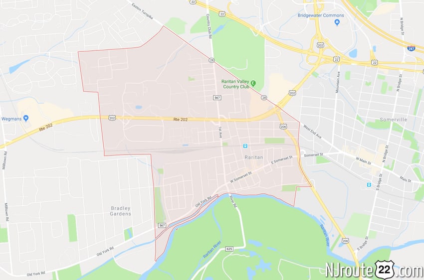
About Raritan, NJ (Borough)
Raritan is noteworthy in NJ due its retail shopping, large corporations, half of the Somerville Circle – and home to a major NJ Transit Station.
It also lies on parts of Route 28, Route 202, Route 206.
Note that this is a borough – and Raritan Township is about 10 miles to the south along 202.
Raritan, New Jersey
Raritan is a borough in Somerset County, New Jersey, United States. As of the 2010 United States Census, the borough’s population was 6,881, reflecting an increase of 543 (+8.6%) from the 6,338 counted in the 2000 Census, which had in turn increased by 540 (+9.3%) from the 5,798 counted in the 1990 Census.
The township’s name is derived from the Raritans, a Native American group of Lenapes. The name of the tribe is said to mean “forked river”, “stream overflows” or “point on a tidal river”.
History

Memorial plaque marking Frelinghuysen estate site and signing of the Knox–Porter Resolution on July 2, 1921.
Raritan town was originally established as a subdivision within Bridgewater Township by an act of the New Jersey Legislature on April 3, 1868. After a series of bitter lawsuits between Raritan and Bridgewater in the 1930s and 1940s, the Legislature allowed Raritan to become a fully independent Borough by an Act on May 12, 1948, based on the results of a referendum passed on June 12, 1948. The new borough incorporated the old town and an additional portion of Bridgewater Township.
The Knox–Porter Resolution ending United States involvement in World War I was signed by President Harding at the estate of New Jersey Senator Joseph Sherman Frelinghuysen, Sr. on July 2, 1921.
Geography
According to the United States Census Bureau, the borough had a total area of 2.037 square miles (5.276 km), including 1.993 square miles (5.162 km) of land and 0.044 square miles (0.114 km) of water (2.15%).
The borough borders Bridgewater Township, Hillsborough Township, and Somerville.
Raritan is in the western division of the Raritan Valley (a line of cities in central New Jersey), along with Branchburg and Bridgewater.
Demographics
| Historical population | |||
|---|---|---|---|
| Census | Pop. | %± | |
| 1870 | 1,009 | — | |
| 1880 | 2,046 | 102.8% | |
| 1890 | 2,556 | 24.9% | |
| 1900 | 3,244 | 26.9% | |
| 1910 | 3,672 | 13.2% | |
| 1920 | 4,457 | 21.4% | |
| 1930 | 4,751 | 6.6% | |
| 1940 | 4,839 | 1.9% | |
| 1950 | 5,131 | 6.0% | |
| 1960 | 6,137 | 19.6% | |
| 1970 | 6,691 | 9.0% | |
| 1980 | 6,128 | −8.4% | |
| 1990 | 5,798 | −5.4% | |
| 2000 | 6,338 | 9.3% | |
| 2010 | 6,881 | 8.6% | |
| Est. 2014 | 8,098 | 17.7% | |
Census 2010
At the 2010 United States Census, there were 6,881 people, 2,673 households, and 1,748 families residing in the borough. The population density was 3,452.2 per square mile (1,332.9/km). There were 2,847 housing units at an average density of 1,428.3 per square mile (551.5/km). The racial makeup of the borough was 76.40% (5,257) White, 2.09% (144) Black or African American, 0.16% (11) Native American, 14.29% (983) Asian, 0.01% (1) Pacific Islander, 4.59% (316) from other races, and 2.46% (169) from two or more races. Hispanics or Latinos of any race were 16.39% (1,128) of the population.
There were 2,673 households, of which 31.2% had children under the age of 18 living with them, 48.5% were married couples living together, 11.2% had a female householder with no husband present, and 34.6% were non-families. 27.8% of all households were made up of individuals, and 10.3% had someone living alone who was 65 years of age or older. The average household size was 2.57 and the average family size was 3.16.
In the borough, 23.1% of the population were under the age of 18, 7.3% from 18 to 24, 28.2% from 25 to 44, 27.8% from 45 to 64, and 13.6% who were 65 years of age or older. The median age was 40.1 years. For every 100 females there were 96.1 males. For every 100 females age 18 and over, there were 95.1 males.
The Census Bureau’s 2006-2010 American Community Survey showed that (in 2010 inflation-adjusted dollars) median household income was $70,116 (with a margin of error of +/- $10,294) and the median family income was $79,813 (+/- $8,715). Males had a median income of $54,130 (+/- $7,617) versus $44,125 (+/- $12,260) for females. The per capita income for the borough was $34,617 (+/- $5,703). About 6.3% of families and 7.4% of the population were below the poverty line, including 15.4% of those under age 18 and 3.5% of those age 65 or over.
Roads and highways
As of May 2010, the borough had a total of 24.34 miles (39.17 km) of roadways, of which 18.26 miles (29.39 km) were maintained by the municipality, 2.85 miles (4.59 km) by Somerset County and 3.23 miles (5.20 km) by the New Jersey Department of Transportation.
U.S. Route 202 traverses the borough from east to west. U.S. Route 206 follows the border with Somerville. New Jersey Route 28 has one side of the roadway within the borough as it follows the border with Bridgewater Township. The northern terminus of County Route 567 is in Raritan.
U.S. Routes 202 and 206 intersect with NJ Route 28 at the Somerville Circle on the borders with Bridgewater Township and Somerville, with the eastern half of the circle located in Raritan. As part of an ongoing effort to improve traffic safety at the circle, the New Jersey Department of Transportation has made a series of changes to the structure of the traffic circle, originally constructed during the 1930s. With the suburbanization of the area, the circle was handling an average of 70,000 vehicles each day. In 1994, an overpass was completed to allow traffic on Route 202 between Flemington and Interstate 78 and Interstate 287 to avoid the circle, though the rate of accidents grew from 195 in 1991 before the project started to 302 for the year after the overpass was open to traffic. After yield signs were added in February 1995, the accident rate increased again, to an annualized rate of 400 per year.
Public transportation
The Raritan train station offers New Jersey Transit service on the Raritan Valley Line to Newark Penn Station. The station is north of the town center on Thompson Street. The station building is south of the tracks in the main parking lot and was built in the early 1890s. There are also three other small lots for this station. Raritan is the last station to the west that is served by all Raritan Valley Line trains. Farther west, service is rush hours only.
The borough is served by the CAT-2R route, operated by Community Access Transit.
Community
Notable people
People who were born in, residents of, or otherwise closely associated with Raritan include:
- John Basilone (1916–1945), awarded the Medal of Honor for his actions at the Battle of Guadalcanal.
- Tony Bongiovi, record producer and recording engineer.
- Isaac Brokaw (1746-1826), clockmaker.
- Ben Carnevale (1915–2008), basketball coach inducted into the Basketball Hall of Fame in 1970.
- Jack Ciattarelli (born 1961), member of the New Jersey General Assembly who has represented the 16th Legislative District since 2011.
- Joseph Sherman Frelinghuysen, Sr. (1869-1948), U.S. Senator representing New Jersey.
- Mike Grosso (born 1947), former professional basketball player who played in the American Basketball Association.
- Elvira Woodruff (born 1951), children’s writer known for books that include elements of fantasy and history.