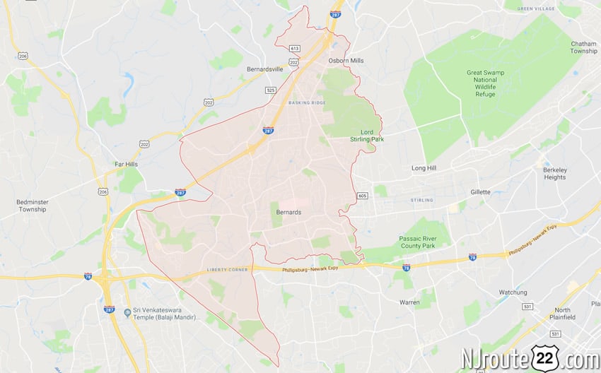
About Bernards, NJ
Bernards, NJ is another fairly large suburb in NJ – with good commuting to NYC and easy access to major highways.
Bernards Township, New Jersey
Bernards Township is a township in Somerset County, New Jersey, United States. At the 2010 United States Census, the township’s population was 26,652, reflecting an increase of 2,077 (+8.5%) from the 24,575 counted in the 2000 Census, which had in turn increased by 7,376 (+42.9%) from the 17,199 counted in the 1990 Census.
History
Bernards Township was originally formed by Royal charter on May 24, 1760, as Bernardston Township from remaining portions of the Northern precinct. It was incorporated as Bernards Township by an act of the New Jersey Legislature on February 21, 1798, as one of New Jersey’s initial group of 104 townships. Portions of the township were taken to form Warren Township (March 5, 1806), Far Hills (April 7, 1921) and Bernardsville (March 6, 1924). Bernards Township celebrated its 250th charter anniversary on May 24, 2010. The township was named for Sir Francis Bernard, 1st Baronet, who served as governor of the Province of New Jersey.
Geography
According to the United States Census Bureau, the township had a total area of 24.061 square miles (62.317 km), including 23.934 square miles (61.988 km) of land and 0.127 square miles (0.330 km) of water (0.53%).
The township is roughly bounded by the Second Watchung Mountain in the southwest, the Dead River swamp on the south, the Great Swamp National Wildlife Refuge, Passaic River, and Millington Gorge in the East.
Unincorporated communities, localities and place names located partially or completely within the township include Basking Ridge, Green Knoll, Hardscrabble, Liberty Corner, Lyons, Madisonville, Mount Horeb, Somerset Mills, State Park, Stone House and White Bridge. Martinsville is an unincorporated area in Bridgewater Township, whose 08836 ZIP code also covers portions of Bernards Township.
The township borders Bedminster Township and Far Hills to the west, Bernardsville to the northwest, Bridgewater Township to the southwest, and Warren Township to the southeast in Somerset County and Harding Township to the northeast and Long Hill to the east in Morris County.
Demographics
| Historical population | |||
|---|---|---|---|
| Census | Pop. | %± | |
| 1790 | 2,377 | — | |
| 1810 | 1,876 | — | |
| 1820 | 2,063 | 10.0% | |
| 1830 | 2,062 | 0.0% | |
| 1840 | 3,986 | 93.3% | |
| 1850 | 2,267 | −43.1% | |
| 1860 | 2,471 | 9.0% | |
| 1870 | 2,369 | −4.1% | |
| 1880 | 2,622 | 10.7% | |
| 1890 | 2,558 | −2.4% | |
| 1900 | 3,066 | 19.9% | |
| 1910 | 4,608 | 50.3% | |
| 1920 | 4,243 | −7.9% | |
| 1930 | 2,293 | * | −46.0% |
| 1940 | 4,512 | 96.8% | |
| 1950 | 7,487 | 65.9% | |
| 1960 | 9,018 | 20.4% | |
| 1970 | 13,305 | 47.5% | |
| 1980 | 12,920 | −2.9% | |
| 1990 | 17,199 | 33.1% | |
| 2000 | 24,575 | 42.9% | |
| 2010 | 26,652 | 8.5% | |
| Est. 2014 | 26,857 | 0.8% | |
| * = Lost territory in previous decade. | |||
Census 2010
At the 2010 United States Census, there were 26,652 people, 9,783 households, and 6,897 families residing in the township. The population density was 1,113.6 per square mile (430.0/km). There were 10,103 housing units at an average density of 422.1 per square mile (163.0/km). The racial makeup of the township was 81.83% (21,809) White, 1.89% (504) Black or African American, 0.08% (20) Native American, 13.80% (3,679) Asian, 0.03% (7) Pacific Islander, 0.55% (147) from other races, and 1.82% (486) from two or more races. Hispanics or Latinos of any race were 3.95% (1,054) of the population.
There were 9,783 households, of which 40.0% had children under the age of 18 living with them, 61.7% were married couples living together, 6.9% had a female householder with no husband present, and 29.5% were non-families. 26.6% of all households were made up of individuals, and 11.3% had someone living alone who was 65 years of age or older. The average household size was 2.65 and the average family size was 3.27.
In the township, 28.8% of the population were under the age of 18, 4.3% from 18 to 24, 20.6% from 25 to 44, 32.9% from 45 to 64, and 13.5% who were 65 years of age or older. The median age was 43.1 years. For every 100 females there were 93.5 males. For every 100 females age 18 and over, there were 88.5 males.
The Census Bureau’s 2006-2010 American Community Survey showed that (in 2010 inflation-adjusted dollars) median household income was $123,285 (with a margin of error of +/- $7,030) and the median family income was $153,906 (+/- $14,565). Males had a median income of $123,390 (+/- $9,621) versus $86,272 (+/- $9,195) for females. The per capita income for the borough was $67,809 (+/- $4,972). About 2.1% of families and 2.9% of the population were below the poverty line, including 1.3% of those under age 18 and 8.0% of those age 65 or over.
Economy
The headquarters of Avaya, Barnes & Noble College Booksellers, Fedders, Hitachi Power Systems USA and Verizon Wireless are located in the township. Verizon Communications, which maintains its world headquarters in New York City, has located operations of its major business units in buildings that were formerly AT&T’s world headquarters.
Roads and highways
As of May 2010, the township had a total of 138.86 miles (223.47 km) of roadways, of which 109.20 miles (175.74 km) were maintained by the municipality, 21.13 miles (34.01 km) by Somerset County and 8.53 miles (13.73 km) by the New Jersey Department of Transportation.
Public transportation
New Jersey Transit train service is available at the Basking Ridge station and Lyons station on the Gladstone Branch, providing service between Gladstone and Hoboken Terminal.
New Jersey Transit provides local bus service on the MCM8 route.
Lakeland Bus Lines provides Route 78 rush-hour service from Bedminster to the Port Authority Bus Terminal in Midtown Manhattan.
Points of interest
- The Devil’s Tree – A solitary oak tree in a field off Mountain Road in the southern corner of the township that has been subject of several stories in Weird NJ magazine.
- The Brick Academy – A restoration of what was known as the Basking Ridge Classical School, a prep school for those hoping to attend Princeton University. The Brick Academy is the current home of the Historical Society of the Somerset Hills.
Notable people
People who were born in, residents of, or otherwise closely associated with Bernards Township include:
- William Alexander, Lord Stirling (1726-1783), Continental Army major general during the American Revolutionary War.
- The Bouncing Souls, punk rock band.
- J. C. Chandor (born 1974), Academy Award-nominated writer/director of the 2011 film Margin Call.
- Chris Daggett (born 1950), President and CEO of the Geraldine R. Dodge Foundation who ran as an independent candidate in the 2009 New Jersey gubernatorial election.
- Scott Fischer (1955–1996), climber and guide who was the first American to climb Lhotse, the fourth-highest mountain in the world; He died on May 11, 1996 in an attempt to climb Mount Everest in the 1996 Everest Disaster.
- Patricia Lee Gauch (born 1934), author of over 30 works of children’s literature who was inducted into the New Jersey Literary Hall of Fame in 1993.
- Jon Gutwillig (born 1974), guitarist of the Disco Biscuits.
- Tobin Heath (born 1988), soccer player and member of the United States women’s national team who won a gold medal as youngest member of the US team in the 2008 Olympics.
- Philip Lindsley (1786–1855), Presbyterian minister, educator, and classicist who served as the acting president of the College of New Jersey (now Princeton University) from 1822 to 1824.
- Page McConnell (born 1963), keyboardist best known for his work with the rock band Phish.
- Robert E. Mulcahy III (born 1932), athletic director at Rutgers University.
- Samuel Lewis Southard (1787–1842), served as U.S. Senator, Secretary of the Navy, and the 10th Governor of New Jersey.
- Mike Tannenbaum (born 1969), former general manager of the New York Jets.
- LaDainian Tomlinson (born 1979), former NFL running back who played for the New York Jets.
- Zip the Pinhead (c. 1842-1926), turn-of-the-century sideshow performer, was born in Liberty Corner.