
About Raritan Township, NJ
Raritan Township, NJ is one of those places, like Phillipsburg, NJ – that we often refer to this area by another name. In this case, most people I know call much of this general area Flemington.
But Flemington, NJ is only one square mile and is completely surrounded by Raritan Township (almost 38 sq. miles.)
And of course – another case of the duplicates – as Raritan Borough is a few miles up the road near Bridgewater.
Regardless, we find ourselves in this Raritan quite a bit – as there is a lot going on. So let’s see where it takes us over time!
Raritan Township, New Jersey
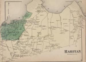
Raritan, NJ – from a wider view.
Raritan Township is a township in Hunterdon County, New Jersey, United States. As of the 2010 United States Census, the township’s population was 22,185, reflecting an increase of 2,376 (+12.0%) from the 19,809 counted in the 2000 Census, which had in turn increased by 4,193 (+26.9%) from the 15,616 counted in the 1990 Census. The southeast part of the township is in the Amwell Valley, while the northwestern part is on the Hunterdon Plateau.
Raritan was incorporated as a township by an act of the New Jersey Legislature on April 2, 1838, from portions of the now-defunct Amwell Township. Flemington was formed within the township on March 14, 1870, and became an independent borough on April 7, 1910. Portions of the township were ceded to East Amwell Township in 1854 and 1897.
The township’s name is derived from the Raritan tribe, a Native American band of Lenape people. The name of the tribe is said to mean “forked river”, “stream overflows” or “point on a tidal river”.
Geography
According to the United States Census Bureau, the township had a total area of 37.690 square miles (97.615 km), including 37.527 square miles (97.194 km) of land and 0.163 square miles (0.422 km) of water (0.43%).
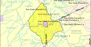
Raritan Township completely surrounds Flemington. It borders Clinton Township, Delaware Township, East Amwell Township, Franklin Township and Readington Township in Hunterdon County; and Hillsborough Township in Somerset County.
Unincorporated communities, localities and place names located partially or completely within the township include Bartles Corners, Cloverhill, Copper Hill, Croton, Flemington Junction, Gary Corner, Klinesville, Larisons Corners, Mount Carmel, Muirhead, Reaville, Rockefellows Mills, Thachers Hill and Voorhees Corner.
Demographics
| Historical population | |||
|---|---|---|---|
| Census | Pop. | %± | |
| 1840 | 2,510 | — | |
| 1850 | 3,070 | 22.3% | |
| 1860 | 2,270 | * | −26.1% |
| 1870 | 2,242 | −1.2% | |
| 1880 | 2,437 | 8.7% | |
| 1890 | 1,821 | −25.3% | |
| 1900 | 1,892 | 3.9% | |
| 1910 | 1,310 | −30.8% | |
| 1920 | 1,677 | 28.0% | |
| 1930 | 1,823 | 8.7% | |
| 1940 | 2,158 | 18.4% | |
| 1950 | 2,814 | 30.4% | |
| 1960 | 4,545 | 61.5% | |
| 1970 | 6,934 | 52.6% | |
| 1980 | 8,292 | 19.6% | |
| 1990 | 15,616 | 88.3% | |
| 2000 | 19,809 | 26.9% | |
| 2010 | 22,185 | 12.0% | |
| Est. 2014 | 22,061 | −0.6% | |
| * = Lost territory in previous decade. | |||
Census 2010
At the 2010 United States Census, there were 22,185 people, 8,056 households, and 6,058 families residing in the township. The population density was 591.2 per square mile (228.3/km). There were 8,288 housing units at an average density of 220.9 per square mile (85.3/km). The racial makeup of the township was 89.57% (19,870) White, 2.07% (459) Black or African American, 0.10% (23) Native American, 5.95% (1,319) Asian, 0.04% (9) Pacific Islander, 0.83% (185) from other races, and 1.44% (320) from two or more races. Hispanics or Latinos of any race were 5.13% (1,138) of the population.
There were 8,056 households, of which 37.6% had children under the age of 18 living with them, 64.9% were married couples living together, 7.7% had a female householder with no husband present, and 24.8% were non-families. 20.7% of all households were made up of individuals, and 8.7% had someone living alone who was 65 years of age or older. The average household size was 2.72 and the average family size was 3.19.
In the township, 26.2% of the population were under the age of 18, 5.9% from 18 to 24, 22.7% from 25 to 44, 33.2% from 45 to 64, and 12.0% who were 65 years of age or older. The median age was 42.4 years. For every 100 females there were 94.8 males. For every 100 females age 18 and over, there were 89.8 males.
The Census Bureau’s 2006-2010 American Community Survey showed that (in 2010 inflation-adjusted dollars) median household income was $109,941 (with a margin of error of +/- $7,543) and the median family income was $130,514 (+/- $10,612). Males had a median income of $95,123 (+/- $8,996) versus $62,229 (+/- $3,584) for females. The per capita income for the borough was $48,782 (+/- $2,900). About 2.0% of families and 4.6% of the population were below the poverty line, including 3.6% of those under age 18 and 6.2% of those age 65 or over.
Transportation
As of May 2010, the township had a total of 181.46 miles (292.03 km) of roadways, of which 146.40 miles (235.61 km) were maintained by the municipality, 22.36 miles (35.98 km) by Hunterdon County and 12.70 miles (20.44 km) by the New Jersey Department of Transportation.
Major roads in Raritan Township include Route 12, Route 31, and U.S. Route 202 (the latter two run concurrent for about four miles (6.4 km) in the southern part of the township).
Major county roads that go through include CR 514 (which runs along the southeastern border), CR 523 and CR 579 (which runs along the southwestern border).
The closest limited access road is Interstate 78 in neighboring Clinton and Franklin Townships.
The Black River and Western Railroad is a historic short-line railroad that passes through the township. It operates today as a heritage railway.
Notable people
People who were born in, residents of, or otherwise closely associated with Raritan Township include:
- Marcia A. Karrow (born 1959), member of the New Jersey Senate who served on the Raritan Township Committee, including in 1998 as its mayor.
- Miles Ross (1827–1903), represented New Jersey’s 3rd congressional district in the United States House of Representatives from 1875 to 1883.
- Alex Shaffer (born 1993), actor who appeared in the 2011 film Win Win.


")


NJ Route 22 Comment Section