About Phillipsburg, NJ
When most people I know say they’re going to “P-burg” (Phillipsburg), they don’t always mean the actual town of Phillipsburg! Most of the “big” destinations out there are located in either Greenwich Township, Pohatcong, or Lopatcong!
Whatever, right? Just a technicality, really.
Below is an “encyclopedia” entry for the town of Phillipsburg:
Phillipsburg, New Jersey
Phillipsburg is a town in Warren County, New Jersey, in the United States. As of 2010 United States Census, the town’s population was 14,950, reflecting a decline of 216 (-1.4%) from the 15,166 counted in the 2000 Census, which had in turn declined by 591 (-3.8%) from the 15,757 counted in the 1990 Census.
Phillipsburg was incorporated as a town by an act of the New Jersey Legislature on March 8, 1861, from portions of Phillipsburg Township (now Lopatcong Township). The town was named for William Phillips, an early settler of the area.
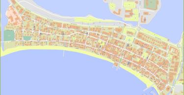
The town is located in western New Jersey, on the border of Pennsylvania, and is considered the eastern border of the region’s Lehigh Valley.
History
The town grew from a sleepy agricultural village (in 1824), and was transformed into a transportation hub and shipping center as the Delaware terminus of the Morris Canal (1829-1924), the first transportation infrastructure project of several, each eventually giving the community a direct connection 107 miles (172 km) to New York City. The Central Railroad of New Jersey would soon follow with a connection, but the community’s growth (and for a long while, its importance) was that it reached the canal terminals of both the Delaware Canal and the Lehigh Canal by its cross-river cable ferry system to Easton, PA. In 1853, the Lehigh Valley Railroad connected across the river with the CNJ and a passenger shortline railroad, the Belvidere Delaware Railroad, as well as the Morris Canal, all within Phillipsburg. Rapid growth followed quickly.
Phillipsburg was incorporated as a town by an act of the New Jersey Legislature on March 8, 1861, from portions of Phillipsburg Township (now Lopatcong Township). The town was named for William Phillips, an early settler of the area.
Geography
According to the United States Census Bureau, the town had a total area of 3.311 square miles (8.575 km), including 3.193 square miles (8.270 km) of land and 0.118 square miles (0.305 km) of water (3.56%).
Unincorporated communities, localities and place names located partially or completely within the town include Andover Furnace, Delaware Park, Lopatcong Heights, Shirmers and Warren Heights.
Pohatcong Mountain is a ridge, approximately 6 mi (9.7 km) long, in the Appalachian Mountains that extends from Phillipsburg northeast approximately to Washington.
Demographics
| Historical population | |||
|---|---|---|---|
| Census | Pop. | %± | |
| 1870 | 5,932 | — | |
| 1880 | 7,181 | 21.1% | |
| 1890 | 8,644 | 20.4% | |
| 1900 | 10,052 | 16.3% | |
| 1910 | 13,903 | 38.3% | |
| 1920 | 16,923 | 21.7% | |
| 1930 | 19,255 | 13.8% | |
| 1940 | 18,314 | −4.9% | |
| 1950 | 18,919 | 3.3% | |
| 1960 | 18,502 | −2.2% | |
| 1970 | 17,849 | −3.5% | |
| 1980 | 16,647 | −6.7% | |
| 1990 | 15,757 | −5.3% | |
| 2000 | 15,166 | −3.8% | |
| 2010 | 14,950 | −1.4% | |
| Est. 2016 | 14,455 | [13][27] | −3.3% |
The Town’s economic data (as is all of Warren County) is calculated by the US Census Bureau as part of the Allentown-Bethlehem-Easton, PA-NJ Metropolitan Statistical Area.
Census 2010
At the 2010 United States Census, there were 14,950 people, 5,925 households, and 3,786 families residing in the town. The population density was 4,682.1 per square mile (1,807.8/km). There were 6,607 housing units at an average density of 2,069.2 per square mile (798.9/km). The racial makeup of the town was 83.44% (12,475) White, 7.49% (1,120) Black or African American, 0.17% (26) Native American, 1.53% (228) Asian, 0.05% (8) Pacific Islander, 3.92% (586) from other races, and 3.39% (507) from two or more races. Hispanics or Latinos of any race were 11.82% (1,767) of the population.
There were 5,925 households, of which 30.7% had children under the age of 18 living with them, 39.0% were married couples living together, 19.0% had a female householder with no husband present, and 36.1% were non-families. 29.9% of all households were made up of individuals, and 12.2% had someone living alone who was 65 years of age or older. The average household size was 2.51 and the average family size was 3.12.
In the town, 25.8% of the population were under the age of 18, 9.3% from 18 to 24, 25.9% from 25 to 44, 25.8% from 45 to 64, and 13.2% who were 65 years of age or older. The median age was 37.1 years. For every 100 females there were 92.7 males. For every 100 females age 18 and over, there were 87.0 males.
The Census Bureau’s 2006-2010 American Community Survey showed that (in 2010 inflation-adjusted dollars) median household income was $42,825 (with a margin of error of +/- $3,386) and the median family income was $51,334 (+/- $3,243). Males had a median income of $44,311 (+/- $2,090) versus $37,673 (+/- $6,847) for females. The per capita income for the borough was $21,291 (+/- $1,061). About 16.5% of families and 18.5% of the population were below the poverty line, including 31.1% of those under age 18 and 6.5% of those age 65 or over.
Census 2000
As of the 2000 United States Census there were 15,166 people, 6,044 households, and 3,946 families residing in the town. The population density was 4,703.6 people per square mile (1,818.5/km). There were 6,651 housing units at an average density of 2,062.8 per square mile (797.5/km). The racial makeup of the town was 91.84% White, 3.47% African American, 0.12% Native American, 0.83% Asian, 0.01% Pacific Islander, 2.02% from other races, and 1.71% from two or more races. Hispanic or Latino of any race were 5.38% of the population.
There were 6,044 households out of which 31.9% had children under the age of 18 living with them, 43.4% were married couples living together, 16.5% had a female householder with no husband present, and 34.7% were non-families. 29.7% of all households were made up of individuals and 13.9% had someone living alone who was 65 years of age or older. The average household size was 2.49 and the average family size was 3.08.
In the town the population was spread out with 26.6% under the age of 18, 7.9% from 18 to 24, 30.1% from 25 to 44, 20.2% from 45 to 64, and 15.2% who were 65 years of age or older. The median age was 36 years. For every 100 females there were 91.0 males. For every 100 females age 18 and over, there were 85.5 males.
The median income for a household in the town was $37,368, and the median income for a family was $46,925. Males had a median income of $37,446 versus $25,228 for females. The per capita income for the town was $18,452. About 9.9% of families and 13.4% of the population were below the poverty line, including 16.6% of those under age 18 and 11.1% of those age 65 or over.
Economy
Industrial history
Phillipsburg had historically benefited from being a major transportation hub, situated at the confluence of the Delaware and Lehigh rivers. Phillipsburg served as the western terminus of the Morris Canal for approximately 100 years from the 1820s to 1920s, which connected the city by water to the industrial and consumer centers of the New York City area, with connections westward via the Lehigh Canal across the Delaware. Long gone is the era of canal shipping and many of the important freight railways that served the area have gone bankrupt or bypass the city on long distance routes.
Phillipsburg was served by five major railroads:
1. Central Railroad of New Jersey (CNJ)
2. Lehigh & Hudson River Railroad (L&HR)
3. Lehigh Valley Railroad (LVRR)
4. Delaware, Lackawanna & Western (DL&W)
5. Pennsylvania Railroad (PRR).
Economic revival
Most of the manufacturing jobs have left Warren County’s largest city. In 1994, the New Jersey Legislature designated Phillipsburg as an Urban Enterprise Zone community. This zoning offers tax incentives and other benefits to Phillipsburg-based businesses, as well as a 3½% sales tax rate at eligible merchants, reduced from the 7% rate charged statewide.
In recent years, some businesses have begun to move into the center of the city. Rising real estate prices indicate that these legislative stimulants have been somewhat effective. Phillipsburg has been selected as a site for the New Jersey Railroad and Transportation Heritage Center (jointly with Netcong), a museum designed to help preserve and showcase the state’s transportation history.
Railway
A tourist railroad known as the Belvidere & Delaware River Railroad operates on the former Belvidere-Delaware Railroad Pennsylvania Railroad Branch serving excursions from Lehigh Junction Station south to Carpentersville. Norfolk Southern serves the industrial manufacturing purposes in Phillipsburg using former LVRR tracks and the L&HR bridge to connect with the Bel-Del PRR tracks.
Since 2007, New Jersey Transit has been conducting a study to determine if re-establishing a commuter rail extension of the Raritan Valley Line to Phillipsburg is economically feasible.
Phillipsburg also is home to the Phillipsburg Railroad Historians museum. They have a display railroad memorabilia inside the museum, an “N” scale diorama, two Lehigh & Hudson River cabooses (one of which is currently being restored) and a Jersey Central caboose. There is a L&HR snow flanger, Tidewater tank car, a CNJ box car owned by the Anthracite Railroads Historical Society, a 1922 Chestnut Ridge Mack railbus owned by the Lehigh Valley NRHS, a Public Service trolley owned by the North Jersey Electric Railway Historical Society, a 44-ton GE locomotive and a 25-ton GE locomotive. They operate a miniature railroad, the Centerville & Southwestern, that formerly ran in Roseland, New Jersey.
Transportation
History

The CNJ tracks and bridge in Phillipsburg which was part of the CNJ main line became part of the former Lehigh Valley Railroad main line, the Lehigh Line now owned by Norfolk Southern Railway, while the PRR line in Phillipsburg is now the Belvidere and Delaware River Railway.
Roads and highways

As of May 2010, the town had a total of 59.21 miles (95.29 km) of roadways, of which 54.51 miles (87.73 km) were maintained by the municipality, 2.98 miles (4.80 km) by Warren County, 1.18 miles (1.90 km) by the New Jersey Department of Transportation and 0.54 miles (0.87 km) by the Delaware River Joint Toll Bridge Commission.
Major highways that enter Phillipsburg include U.S. Route 22 and Route 122. Interstate 78 passes through for less than a quarter-of-a-mile without any exits, but the closest interchange is in neighboring Pohatcong.
The town is connected to Pennsylvania across the Delaware River by the Easton–Phillipsburg Toll Bridge – (toll bridge carrying U.S. Route 22), Northampton Street Bridge (the “Free Bridge”) and the Interstate 78 Toll Bridge (carrying Interstate 78), all of which are operated by the Delaware River Joint Toll Bridge Commission.
Public transportation
New Jersey Transit bus service is provided on the 890 and 891 routes. It is also served by a bus line down Route 57 to Washington Township.
By air, Phillipsburg is served by Lehigh Valley International Airport.
Notable people
People who were born in, residents of, or otherwise closely associated with Phillipsburg include:
- Walter Ellsworth Bachman, Sr. (1880–1958), college football player and coach.
- Charlie Berry (1860–1940), former professional baseball player, Union Association, and father of Charlie Berry.
- Charlie Berry (1902–1972), former professional baseball and umpire, Major League Baseball.
- William F. Birch (1870–1946), former Member of Congress.
- Ned Bolcar (born 1967), former linebacker who played for the Seattle Seahawks and Miami Dolphins.
- Tom Brennan (born 1949), radio and television sportscaster and former men’s basketball head coach, most notably at the University of Vermont.
- Tim Brewster (born 1960), former coach of the Minnesota Golden Gophers football team.
- Ted Dailey (1908-1992), NFL player who played for a single season with the Pittsburgh Pirates football team.
- DC Drake (born 1957 as Don Drake), former professional wrestler who was National Wrestling Federation World Champion and Heavyweight Champion for Tri-State Wrestling Alliance, later known as Extreme Championship Wrestling (ECW).
- Wayne Dumont (1914–1992), former New Jersey Senate Majority Leader and Senate President.
- Fiona (born 1961), rock music singer.
- James Cullen Ganey (1899–1972), federal judge who served on the United States Court of Appeals for the Third Circuit.
- John R. Guthrie (1921–2009), United States Army four-star general.
- David Hajdu (born 1955), music critic and author.
- Terry Kitchen, folk singer.
- J. Robert Lennon (born 1970), novelist.
- Hilda Madsen (1910–1981), British-American artist and dog breeder.
- Jayne Mansfield (1933–1967), 1950s-era actress and sex symbol.
- Martin O. May (1922–1945), Medal of Honor recipient in World War II for his actions on Okinawa.
- Helen Stevenson Meyner (1929–1997), former Member of Congress.
- Robert B. Meyner (1908–1990), Governor of New Jersey from 1954 to 1962.
- Lou Reda (born c. 1925), documentary filmmaker.
- Jim Ringo (1931–2007), professional football player who played with the Green Bay Packers and Philadelphia Eagles.
- Sheetal Sheth, actress.
- Charles Sitgreaves (1803–1878), politician who was a Member of Congress and mayor of Phillipsburg.
- Bill Walsh (born 1927), center who played in the NFL for the Pittsburgh Steelers.
- Yvonne Zima (born 1989), actress, “Rachel Greene” on NBC‘s ER.
(SOURCE: Infogalactic)